Mississippi news: Gulf odds reach 90% as Saturday flood threat emerges
Morning edition — Tuesday, October 6, 2026
Mississippi’s next weather concern is taking shape: the Gulf disturbance now has a 90% chance of becoming a tropical system, and NWS Jackson has added a Saturday flash-flood outlook. Hazardous boating conditions have already begun in Mississippi Sound. Inland, today remains mostly dry and warm, with fire danger continuing in the north. This morning’s local updates include a Hernando road closure, Madison’s events tonight, a new statewide absentee-ballot count and Thursday’s public zoning meeting in Olive Branch.
Gulf disturbance’s two-day development chance climbs to 90%
The National Hurricane Center’s 7 a.m. CDT Tuesday outlook gives disturbance AL92 a 90% formation chance over both the next 48 hours and seven days. That increases the two-day probability from 70% and the seven-day probability from 80% in Monday evening’s briefing.
NHC now reports signs of organization around a broad low-pressure area in the southwestern Gulf. A tropical depression is anticipated within the next day or so as the system initially drifts east. Forecasters expect it to turn north or northeast toward the northern Gulf Coast by the end of the week.
The federal outlook still cannot specify northern Gulf Coast impacts. Its percentages describe formation, rather than a Mississippi landfall chance. Interests from Louisiana to the Florida Panhandle should monitor the system. NOAA’s Gulfstream aircraft is scheduled to sample its surrounding environment today, with an Air Force reconnaissance investigation planned Wednesday. Those are planned flights, not completed observations.
New Saturday outlook flags possible inland flash flooding
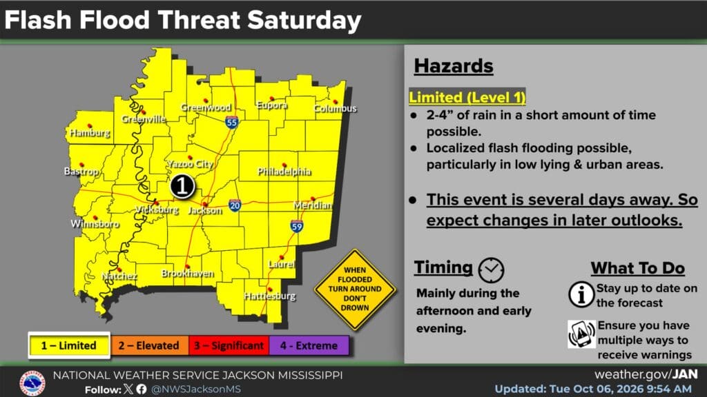
NWS Jackson’s graphic updated at 9:54 a.m. Tuesday places its forecast region under a limited, Level 1 flash-flood threat for Saturday, October 10. It identifies the possibility of 2–4 inches of rain in a short period, mainly during the afternoon and early evening, with localized flooding especially in low-lying and urban areas.
This adds a specific inland flooding concern to last evening’s coastal rain outlook. The Jackson discussion updated at 6:43 a.m. says excessive-rainfall guidance has prompted an area-wide limited flooding outlook. Exact totals and impacts remain uncertain several days ahead.
The graphic is an advance outlook, not an active Saturday flood warning. Its shaded area follows the Jackson forecast region, rather than all Mississippi counties. Residents planning weekend travel or outdoor activities should watch later forecasts and have multiple ways to receive warnings. The forecast’s timing and placement may change as the disturbance organizes.
Mississippi Sound small-craft advisory is now in effect
The 12:13 a.m. Tuesday marine message retains the small-craft advisory that began at 7 a.m. today and continues until 3 a.m. Friday, October 9. It includes Mississippi Sound, Chandeleur and Breton sounds, Lake Borgne and listed Gulf waters east of the Mississippi River’s mouth.
Northeast winds of 20–30 knots and seas of 6–9 feet are forecast across the advisory’s waters. NWS says conditions are hazardous to small craft and advises inexperienced mariners, especially in smaller vessels, to avoid hazardous navigation.
The 5:55 a.m. coastal discussion anticipates worsening marine conditions after today, with open-water seas potentially reaching 9–12 feet late in the week. That later forecast is separate from the current advisory’s 6–9-foot range and should not be applied uniformly to sheltered waters. The disturbance’s eventual track will influence coastal rainfall; forecasters still describe substantial uncertainty.
Warm, dry inland Tuesday; northern fog possible Wednesday
Jackson’s morning forecast lists Tuesday highs of 89 in Jackson and Natchez, 87 in Meridian and Hattiesburg, 90 in Vicksburg and Greenwood, and 88 in Greenville. All seven locations now have zero daytime rain probability in the table. Vicksburg’s chance was 10% last evening; Jackson’s forecast high has risen from 87 to 89.
The 6:21 a.m. Memphis discussion keeps elevated fire danger through Friday because of low afternoon humidity. It forecasts humidity below 30% across much of its region today, with light winds, and gradually warmer afternoons through late week.
A warm front is expected to lift into north Mississippi tonight and stall before daybreak Wednesday. Patchy fog could develop in northeast Mississippi as moisture increases near that boundary. Allow for changing visibility on Wednesday’s commute. Follow local burn restrictions; this weather outlook does not itself establish a county burn ban.
Hernando drivers face McIngvale Road detours today
A portion of McIngvale Road near Dilworth Lane S is scheduled to close today while a contractor connects the Captain D’s development to a water line. The original Hernando announcement, shared by DeSoto County Government, says the work was timed for Fall Break to avoid school traffic.
Use Thousand Oaks Drive on the north side or Creekside Boulevard on the south side. Vehicles approaching from the south may continue past Creekside, but cannot travel through the work area and must turn around before the closure.
Our fuller road report explains the access arrangement. The announcement gives no firm reopening time. Follow posted detour and closure signs rather than assume the road has reopened later in the day.
Madison National Night Out includes an early shelter stop
Madison’s National Night Out is scheduled tonight, October 6, from 6–9 p.m. The police department’s original schedule also includes a Webster Animal Shelter stop from 5–6 p.m., before the main event window.
Whittington Subdivision and Bradford Place are listed for 6–6:30 p.m.; Natchez Trace Village for 6:30–7 p.m.; and Geneva Gardens for 7:30–8 p.m. These are the posted individual stops, rather than a claim that each location runs the entire evening.
The department describes the event as a way to build neighborhood and police-community relationships. For participation details, call 601-856-6111 or email Lt. Micah Taylor at mtaylor@madisonpd.org. See our complete local report before planning a visit.
New absentee report counts 9,761 ballots returned statewide
The Secretary of State’s October 5 report, newly covered in this edition, says Mississippi’s election system recorded 15,170 absentee ballots requested, 14,771 sent and 9,761 received for the November 3 general election.
Those figures represent different stages: voter requests, ballots sent by circuit clerks and completed ballots returned to clerks. They are not election results or a count of votes cast for any candidate.
The report links to a sample ballot and the My Election Day tracking portal for voters who requested absentee ballots. In-person absentee voting ends Saturday, October 31; mailed absentee ballots must be postmarked by Election Day, November 3. Questions can go to local circuit clerks or the state Elections Hotline at 1-800-829-6786. Yesterday’s voter-registration deadline has passed; these absentee dates are separate requirements.
Olive Branch posts Thursday zoning agenda for public review
The Olive Branch Board of Zoning Adjustment will meet Thursday, October 8, at 6 p.m. in the City Municipal Court Building, 6900 Highland Street. The city’s notice says the meeting is open to the public and the agenda remains subject to updates.
The October 8 agenda is listed in the city’s Agenda Center. Staff reports are available through the Planning and Development department. Residents can review those materials before Thursday instead of waiting until the meeting to find the relevant documents. Today’s community briefing has this and additional local notices.
Featured graphic: NWS Jackson’s Saturday flash-flood outlook, updated October 6, 2026, at 9:54 a.m. Credit: National Weather Service Jackson. This advance forecast may change; it is not an active flood warning. Federal NWS material is public domain.
Compiled with AI assistance from Mississippi News Group coverage and linked official sources. See our editorial standards.