Mississippi news: Southern rain outlook eases as Gulf development risk emerges
Evening edition — Sunday, October 4, 2026
Southern Mississippi’s flood watch continues tonight, but the latest update lowers the amount of additional rain expected before midnight. A separate Gulf disturbance now warrants attention for the week ahead. Inland communities face a much drier Monday than the Coast, while newly posted state cancer data offer a clearer picture of Mississippi’s health burden. Here are the forecast changes, health findings and service deadlines to know before the workweek begins.
Southern flood watch holds as expected additional rain decreases
The National Weather Service’s 3:05 p.m. flood-watch update keeps Hancock, Harrison, Jackson, Pearl River, Pike and Walthall counties covered until midnight CDT tonight. Northern and southern portions of all three coastal counties remain included.
The new product calls for another 1–3 inches, with locally higher amounts possible, through midnight. That is down from the additional 3–5 inches in the overnight watch discussed in this morning’s briefing. The change concerns rain still to come; it does not revise how much has already fallen or establish that flooding has ended.
The 6:48 p.m. New Orleans/Baton Rouge discussion retains rain and embedded thunderstorms through the evening. Its earlier daytime analysis expects the front to reach the Coast and Gulf late tonight or early Monday, with the longest-lasting rain in Mississippi’s coastal counties.
People near creeks, poorly drained streets and other flood-prone places should monitor later warnings. A watch identifies the possibility of flooding; it does not mean every location is flooded. Avoid driving into water of unknown depth.
Gulf outlook adds a development risk for late this week
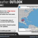
The National Hurricane Center’s 7 p.m. CDT outlook gives a southwestern Gulf disturbance a 40% chance of tropical formation within seven days, while keeping its 48-hour chance near zero. Forecasters expect an area of low pressure to form around midweek and say a tropical depression could develop late in the week as the system drifts northward.
This is a development outlook, not a forecast of a named storm striking Mississippi. Environmental conditions are expected to be only marginally favorable, and the timing, strength and eventual path remain unsettled.
NWS Memphis’s Sunday afternoon analysis likewise says it is too early to specify Mid-South impacts. Coast residents and people planning late-week travel should follow subsequent official outlooks as the system becomes better defined.
Monday rain chances drop inland, but the Pine Belt keeps a chance
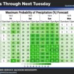
The 2:08 p.m. NWS Jackson discussion puts overnight rain chances at 60% for Meridian and Hattiesburg, 40% for Jackson and Natchez, and 20% for Vicksburg. The Delta’s Greenville and Greenwood forecasts are at 10% tonight.
Monday’s daytime forecast falls to 30% in Hattiesburg, 20% in Meridian and 10% in Jackson, Natchez and Vicksburg. Greenville and Greenwood show zero. Jackson’s Monday chance has risen from zero in the morning table to 10%, while the Meridian and Hattiesburg values are unchanged.
Forecasters expect moisture to decrease from north to south. Monday highs in the listed cities range from 84 to 87 degrees, with the principal reinforcing push of dry air expected around midweek. That uneven drying matters for school, work and outdoor plans: a lower statewide rain trend still leaves parts of southeast Mississippi with a chance of showers.
North Mississippi’s fire-weather outlook shifts later in the week
NWS Memphis’s updated evening discussion expects a reinforcing front tonight, followed by cooler, drier weather Monday and Tuesday. Its afternoon fire-weather section places minimum humidity generally between 30% and 40% on those two days, compared with the morning discussion’s emphasis on values near 30% south of I-40.
The more pronounced drying is expected from Wednesday onward, when humidity could reach 30% or lower as temperatures rise. Forecasters say light winds and recent wetting rains should limit the higher-end fire threat.
Use care with outdoor burning and follow locally issued burn restrictions. The discussion is a weather assessment; it does not create a county burn ban or establish that one applies to your address.
Recently posted cancer fact sheet reports 6,526 deaths in 2023
A cancer fact sheet listed on MSDH’s October 2 website update reports more than 17,500 new cancer cases and 6,526 cancer deaths in Mississippi during 2023. The document covers 2019–2023 and is marked updated June 2026; these are historical registry figures, not a count of cases diagnosed this weekend.
Across those five years, MSDH reports 86,584 new cases and 32,983 deaths. The agency ranks Mississippi second nationally for cancer mortality and 13th for incidence over the reporting period. The distinction helps explain why a high death burden deserves attention even when the state’s new-case ranking is lower.
The sheet emphasizes screening, vaccination and reducing preventable risks. Screening needs vary by age and medical history; discuss the appropriate schedule with a health professional. For practical help, our recent community coverage points to MSDH’s Breast and Cervical Cancer Program for eligible Mississippi women.
UMMC funding report shows reach beyond Jackson
A September 21 UMMC report, newly included in these headline briefings, says the medical center secured more than $103.3 million through 303 sponsored awards in fiscal 2026. About $49.7 million came from the National Institutes of Health.
The report describes 44 activated clinical trials and programs supporting rural physician training, cardiovascular research and remote care. UMMC says a rural critical-care telehealth effort served more than 280 patients at Copiah County Medical Center, Greenwood Leflore Hospital and Magee General Hospital during the fiscal year.
Those examples show how research and sponsored-program money can reach communities outside the capital. They are UMMC’s reported fiscal-year results, not a new grant announced Sunday or proof that every funded project has produced a completed treatment. The university also describes support for clinical training in Grenada and Lexington, linking its research portfolio with Mississippi’s physician workforce.
Monday brings voter deadline and Pascagoula records closure
Two previously announced changes are worth checking before a Monday office visit. The Secretary of State’s registration notice sets October 5 as the deadline to register in person at a circuit clerk’s office or mail an application postmarked by that date for the November 3 general election. Confirm your local office hours and check registration information through the state’s linked Y’all Vote services.
In Pascagoula, the Police Department’s Records Division is scheduled to close October 5–9 for staff training. Our full service notice explains the online accident-report option and directs fingerprint customers to surrounding agencies. These are next-day reminders, not new extensions or closures announced tonight.
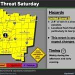
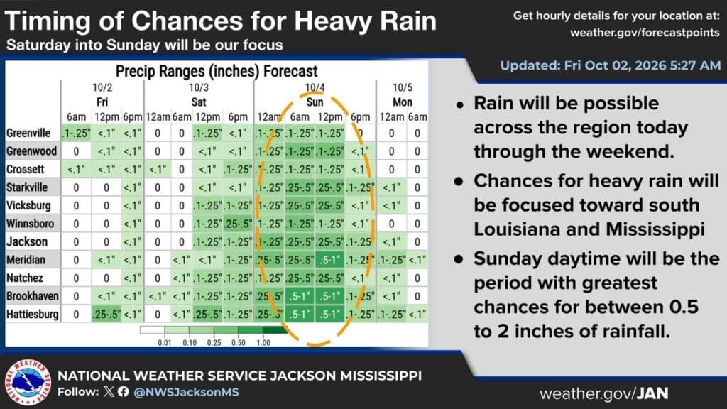
Featured graphic: NWS Jackson’s October 2, 2026, 5:27 a.m. inland rain-timing forecast, used as a dated illustration of this weekend’s rain. Current Sunday evening forecasts and the separate southern flood watch are explained above. Credit: US National Weather Service Jackson Mississippi.
Compiled with AI assistance from Mississippi News Group coverage and linked official sources. See our editorial standards.