NWS issues severe thunderstorm watch for Arkansas, Louisiana, Mississippi until 6 p.m. CDT
The National Weather Service issued Severe Thunderstorm Watch 241 in effect until 6 p.m. CDT Thursday for parts of Arkansas, Louisiana and Mississippi, the agency said.
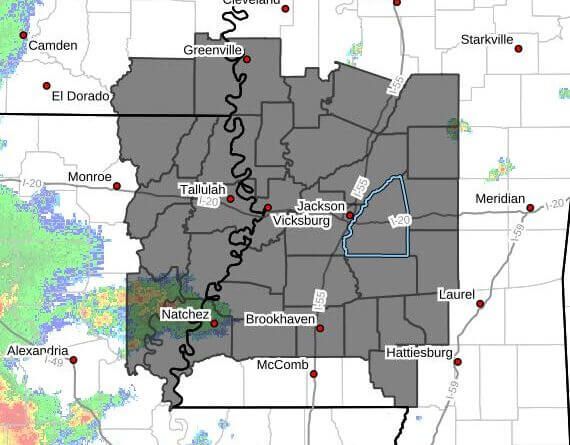
The watch covers two counties in southeast Arkansas — Ashley and Chicot — and nine parishes in northeast Louisiana: Catahoula, Concordia, East Carroll, Franklin, Madison, Morehouse, Richland, Tensas and West Carroll, the NWS said.
In Mississippi the watch includes 25 counties in central Mississippi — Attala, Copiah, Hinds, Holmes, Humphreys, Leake, Madison, Rankin, Scott, Simpson, Smith and Yazoo — as well as Washington in northwest Mississippi; Jefferson Davis, Lawrence, Lincoln and Marion in south central Mississippi; Covington in southeast Mississippi; Adams, Claiborne, Franklin and Jefferson in southwest Mississippi; and Issaquena, Sharkey and Warren in west central Mississippi, the agency said.
The NWS listed numerous cities within the watch area, including Anguilla, Bastrop, Belzoni, Brandon, Brookhaven, Canton, Crossett, Crystal Springs, Delhi, Dermott, Durant, Eudora, Fayette, Ferriday, Forest, Greenville, Hamburg, Hazlehurst, Jackson, Kosciusko, Lake Providence, Lake Village, Lexington, Madison, Magee, Mayersville, Monticello, Natchez, Pearl, Port Gibson, Ridgeland, Rolling Fork, Tallulah, Vicksburg, Vidalia, Wesson, West Crossett and Yazoo, among others.
A severe thunderstorm watch means conditions are favorable for the development of severe storms capable of producing damaging winds and hail. The NWS advises residents to monitor local forecasts and be prepared to take shelter if warnings are issued. This is a developing story and will be updated as more details emerge.


