Mississippi news: Isaias reaches 65 mph as Medicaid urges plan review
Evening edition — Wednesday, October 7, 2026
Tropical Storm Isaias has strengthened to 65 mph, and its expected inland track is shifting farther east and moving faster. Mississippi coastal residents still face hurricane and storm-surge watches, while forecasters sharpen the Friday-night wind and rain outlook for eastern parts of the state.
Tonight’s briefing adds a statewide Medicaid plan-choice reminder, localized water notices, Lafayette County’s new burn ban and an approaching judicial campaign-finance deadline. The storm update builds on our morning edition, refreshed early Wednesday afternoon; the other items were not included there.
Isaias reaches 65 mph as coastal preparations continue
The National Hurricane Center’s 7 p.m. Wednesday advisory keeps Isaias a tropical storm, with maximum sustained winds of 65 mph and movement east-northeast at 8 mph. It forecasts hurricane strength by Thursday morning and landfall along the northern Gulf Coast late Friday or early Saturday. That is a forecast, not a report that Isaias is already a hurricane.
The national advisory lists a hurricane watch from Bay St. Louis eastward to Indian Pass, Florida, and a storm-surge watch from the mouth of the Mississippi River to Yankeetown, Florida. Watches mean hazardous conditions are possible; they do not mean those conditions have begun. The 7 p.m. advisory reports no watch or warning changes from its preceding advisory.
NHC projects potential water levels above ground of 3–5 feet from the Mississippi River’s mouth to Ocean Springs and 5–7 feet from Ocean Springs eastward to Indian Pass if peak surge coincides with high tide. These ranges vary by location and tidal timing. They should not be treated as a uniform water depth across a county.
The 4:02 p.m. local NWS statement also lists hurricane watches for northern Harrison and northern Jackson counties, underscoring that preparation concerns extend inland from the immediate shore. It urges residents to finish outside preparations before conditions worsen, consider safe shelter if vulnerable to wind or flooding, and follow local evacuation advice. MEMA’s Isaias resource page connects readers with forecast and preparedness information.
Eastern Mississippi wind outlook sharpens; Thursday stays hot and dry
In its 4:05 p.m. Wednesday discussion, NWS Jackson describes a marked eastward and faster shift in forecast guidance over the preceding 24 hours. Forecasters now see a greater likelihood that the center will pass east of Mississippi, with the heavier rain and strongest winds focused on eastern parts of their region.
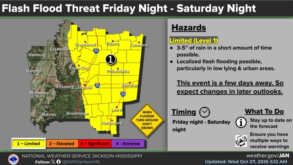
The office identifies possible gusts of 30–40 mph mainly east of Interstate 55 beginning Friday evening and continuing at least into Saturday morning. It retains a limited flash-flood outlook for eastern and northeastern Mississippi, while saying the degree of outdoor-event disruption remains uncertain. An eastward track does not remove the possibility of a rain and wind band west of the storm’s center.
Before that weather arrives, Thursday brings another hot, dry day: the office’s point forecast lists highs of 92 in Jackson, 90 in Meridian and 93 in Greenville. It also identifies increasing fire danger Thursday, especially in western and northern portions of its region. Rain preparations and attention to burning restrictions are both relevant this week.
Lafayette County’s 30-day burn ban covers outdoor burning
Lafayette County’s October 6 announcement says supervisors approved a countywide burn ban Monday night because of drought and a lack of rain. The county says it took effect immediately and lasts 30 days unless the board lifts it sooner, including in unincorporated areas.
An EMA notice shared Tuesday from the county fire department specifies brush piles, yard debris, household waste, fields, pastures, ditch lines, campfires, bonfires, burn barrels and other open-flame outdoor burning. It also asks residents to watch sources of sparks, including discarded cigarettes, hot equipment in dry grass and vehicles over tall, dry vegetation.
The practical distinction is between a forecast of rain and an official end to the ban. The county says supervisors will review rainfall and fuel moisture before lifting it. Residents who see smoke or flames should call 911. Our October 7 community briefing includes the local fire notice and other community coverage.
New Medicaid reminder gives members a plan-review window
The Mississippi Division of Medicaid’s October 7 notice reminds MississippiCAN and Children’s Health Insurance Program members that annual open enrollment is their opportunity to review or change managed-care plans. Plan changes take effect January 1, 2027.
The agency’s 2026 enrollment instructions specify an October 1–December 15 window. Members may stay with their current plan or switch to another; the agency says a member can switch only once during this opportunity. A satisfied member does not need to change plans.
The enrollment page provides separate MississippiCAN and CHIP comparison charts and a link to the enrollment portal. Reviewing the chart for the correct program can help members compare available options before making a choice. This announcement concerns plan selection for existing members; it should not be read as a promise that everyone who applies qualifies for Medicaid.
For a mailed paper enrollment form or language assistance, the division gives 800-421-2408. With changes taking effect in January rather than immediately, members have time to review the agency’s instructions and seek assistance before the December deadline.
Richland and Laurel water notices apply to specified customers
MSDH’s active-notice list Wednesday evening still includes two localized notices issued October 6. The Richland notice in Rankin County identifies affected customers at Vicksburg even-numbered locations and Lexington odd-numbered locations. Readers should check those listed locations rather than assume every customer in Richland is affected.
The Laurel notice in Jones County affects approximately eight customers at the mobile-home park at 1608 Bush Dairy Road: meters 1W, 2W, 3W, 8W, 10W, 14W, 16W and 22W. These are existing October 6 notices, not new notices issued tonight, and neither was covered in this morning’s briefing.
The agency says pressure loss from line breaks prompted the notices. It recommends bringing water to a vigorous boil for one minute before consumption and using boiled or bottled water for brushing teeth. Ice made with untreated water is not made safe simply by freezing it. A return of pressure alone is not the official lifting of a notice; affected customers should wait for the water system’s clearance after testing.
Judicial campaign-finance reports are due Friday afternoon
The Secretary of State’s October 5 deadline notice says periodic campaign-finance reports for all nonpartisan judicial candidates and committees are due by 5 p.m. Friday, October 9. Thursday is the final full weekday before that deadline.
Reports may be submitted by email to CampaignFinance.common@sos.ms.gov, in person at 401 Mississippi Street in Jackson, by fax to 601-576-2545, or by mail to P.O. Box 136, Jackson, MS 39205-0136. Mailed reports must actually arrive by the deadline; the office says the postmark does not count.
The notice applies to those judicial candidates and committees. It is separate from voter registration and absentee voting. Campaign-finance or election questions can be directed to the Elections Division at 800-829-6786 or ElectionsAnswers@sos.ms.gov.
Featured graphic: NWS Jackson’s October 7, 5:12 a.m. regional flash-flood outlook for Friday night through Saturday night. Credit: National Weather Service Jackson. This advance outlook is not an active flood warning; the newer afternoon discussion is summarized above.
Compiled with AI assistance from Mississippi News Group coverage and linked official sources. See our editorial standards.