Mississippi news: Friday Hancock flood advisory, I-20 ramp closure and Halloween outlook
Morning edition — Thursday, October 29, 2026
Southern Hancock County faces another overnight coastal-flooding window, while Mississippi drivers have a newly posted I-20 ramp closure to navigate today. This morning’s Mississippi news briefing also tracks a revised Halloween rain forecast, construction starting at Mississippi State, health guidance for infant caregivers and new community and arts coverage from Hattiesburg and Meridian.
Southern Hancock advisory shifts to early Friday
The National Weather Service’s 5:14 a.m. Thursday coastal-hazard message lists a coastal flood advisory for Southern Hancock County from 1 a.m. to 5 a.m. CDT Friday, October 30. Minor flooding of lots, parks and roads is expected, with isolated road closures possible.
This is a different window from the Wednesday-night-to-Thursday-morning advisory covered in last evening’s briefing. Residents with flood-prone property and people traveling before dawn Friday should plan around the new hours rather than reuse the earlier expiration time.
The New Orleans/Baton Rouge office’s overnight discussion links the concern to persistent easterly winds and high tides. It says additional locations could need attention later in the weekend; that is a forecast possibility, not an advisory already issued for the entire Mississippi Coast. Follow barricades and avoid water of unknown depth.
Halloween outlook adds earlier Delta showers; fire danger persists today
The Jackson office’s 3:05 a.m. discussion, retained in its 6:40 a.m. update, now allows showers around the ArkLaMiss and Delta as early as Saturday morning. Elsewhere in that forecast area, scattered rain may largely wait until Saturday afternoon or evening and continue into Sunday. Thunderstorms are possible, but forecasters do not expect severe weather with the weekend system.
That geographic distinction matters for Halloween plans: a later arrival in one community does not promise a dry Saturday everywhere. Keep a local forecast and an alternate plan handy.
For northern Mississippi, the Memphis office’s overnight outlook favors a relatively modest rain event. Portions of northeast Mississippi could exceed three-quarters of an inch Saturday into Sunday, while much of its broader forecast region may get less than half an inch.
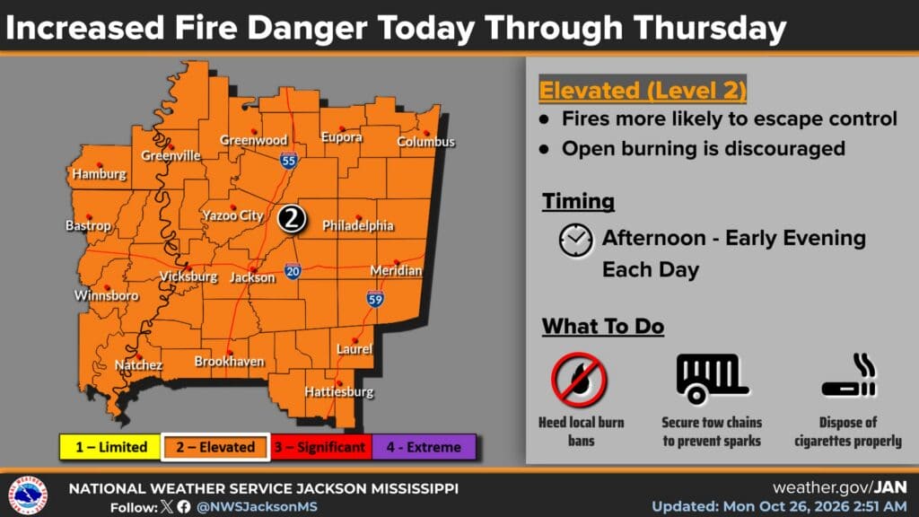
Before that moisture arrives, dry ground and low humidity still elevate today’s fire concern. Higher humidity will reduce that weather contribution in coming days, Jackson forecasters say, but areas missing meaningful rain will retain dry ground. The separate county restrictions described in our Lowndes County coverage and Kemper County coverage are not canceled by a changing forecast.
Warren County’s westbound I-20 Exit 15 closes today
MDOT’s live traffic listing, updated at 9:07 a.m., reports the westbound I-20 exit ramp to Flowers/Ceres Boulevard, Exit 15, closed for resurfacing in Warren County. The posted work window is 9 a.m. to 3 p.m. Thursday. This is an exit-ramp restriction, not a closure of the entire westbound interstate.
Drivers who normally leave the interstate at Flowers/Ceres Boulevard should plan a different exit during the posted work window. Check the live record before departure, because work schedules can change and the listed completion time is an estimate.
Stone Boulevard lighting work starts today
Mississippi State says a recreational-field lighting project begins Thursday, October 29, along Stone Boulevard. Its October 28 construction announcement says Stone Boulevard, Famous Maroon Band Street and nearby sidewalks will remain open.
The immediate change for campus travel is construction activity, rather than a street shutdown. Drivers and pedestrians should use caution through the work area. The university expects work to continue through February and lists its Facilities Management Service Desk, 662-325-2005, for questions.
MSDH reminds every infant caregiver about safe sleep
In an October 28 public message, the Mississippi State Department of Health emphasized that infant safe-sleep practices apply to daytime naps as well as nighttime sleep.
The agency advises placing babies on their backs on a firm, flat surface in their own crib or bassinet, with blankets, pillows, toys, bumpers and other soft items kept out of the sleep space. Its message specifically includes grandparents, relatives and babysitters among the caregivers who should follow the same practices. This is prevention guidance, not an announcement of a new local incident or outbreak.
Southern Miss marks a decade of disability self-advocacy videos
A Southern Miss feature published October 28 reports that Taylor Carley’s online interview project has reached its tenth anniversary and 414 videos. Carley is self-advocacy coordinator at the university’s Institute for Disability Studies.
The monthly YouTube series, Chit Chat Thursdays with Taylor, covers self-advocacy, community efforts, disability issues and the Americans with Disabilities Act. The university describes support from a Southeast ADA Center collaborative grant and the institute’s core funding.
The feature links viewers to the series and describes spin-offs that give other self-advocates opportunities to present their interests. It also notes Carley’s graduation last spring through RISE, a postsecondary program for people with intellectual and other developmental disabilities. The anniversary is the newly covered milestone; the report does not announce a new statewide benefit or enrollment opening.
Meridian concert announcement gives residents a November date
Mississippi State’s October 28 Riley Center announcement lists blues singer and guitarist Keb’ Mo’ for Friday, November 13, at 7:30 p.m. in Meridian. The five-time Grammy winner’s concert tickets are advertised at $35–$85.
The release links online ticket purchasing and gives the Riley Center Box Office at 2200 Fifth Street, 601-696-2200, for information. Check current availability through that official link before making plans; the announcement’s price range does not guarantee a particular seat remains available.
Featured image: NWS Jackson’s October 26, 2026, 2:51 a.m. CDT fire-danger graphic, used unaltered as dated regional context through Thursday. It is not a coastal-flood or county burn-ban map. Credit: National Weather Service Jackson; public-domain graphic.
Compiled with AI assistance from Mississippi News Group coverage and linked official sources. See our editorial standards and sourcing disclosure.