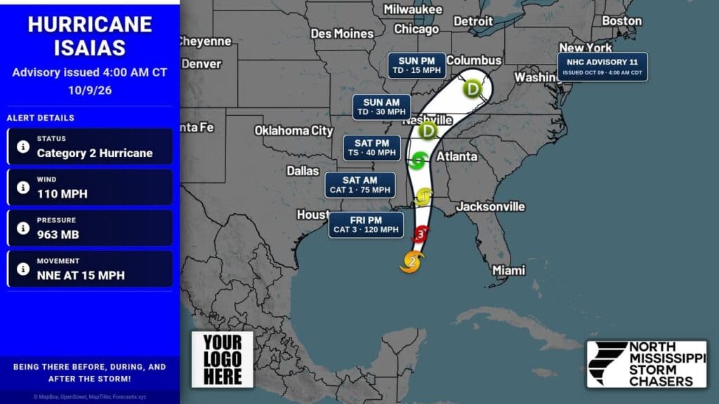
Hurricane Isaias was strengthening Friday morning as it moved north-northeast toward the U.S. northern Gulf Coast, with maximum sustained winds of 110 mph and higher gusts. Air Force and NOAA Hurricane Hunter data indicated the storm was likely to become a major hurricane that morning.
The storm was expected to approach the northern Gulf Coast Friday afternoon and make landfall within the warning area Friday night or early Saturday. A Hurricane Warning was in effect from Ocean Springs, Mississippi, to the Bay-Gulf County line in Florida, while a Tropical Storm Warning covered areas from the Jefferson-Plaquemines Parish line to west of Ocean Springs and from east of the Bay-Gulf County line to the Aucilla River.
ADVERTISEMENT
A Storm Surge Warning covered the Mouth of the Mississippi River to the Suwannee River. Forecast water levels ranged from 3 to 5 feet from the Mississippi River mouth to Dauphin Island, Alabama, and from 5 to 7 feet between Dauphin Island and Indian Pass, Florida. The deepest water was expected along the immediate coast where onshore winds coincide with surge and dangerous waves.
Preparations should be rushed to completion because weather conditions were expected to deteriorate quickly Friday, according to the notice. Rainfall of 4 to 8 inches, with localized totals up to 15 inches, was expected across parts of Alabama, Florida and Georgia, with flash, urban and river flooding possible. A tornado risk was also expected to begin Friday afternoon in coastal Alabama, the Florida Panhandle and southwest Georgia.
Jon Ross Myers founded Mississippi News Group in 2013. Before founding the organization, he worked at The Daily Mississippian, The Marion Salute and The Southern Sentinel. A Mississippi journalist and writer based in Ripley, he received second place in poetry in the 2025 William Faulkner Literary Competition for "The Garden."
Stay connected
Mississippi, wherever you are.
Follow our coverage on Facebook and watch Mississippi News Group on YouTube.