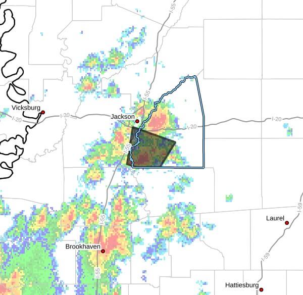
A weather update posted to social media at 1:31 p.m. CDT Thursday warned that strong thunderstorms would impact southeastern Hinds and southwestern Rankin counties through 2:15 p.m. CDT, with wind gusts up to 50 mph, the alert said.
At 1:31 p.m., Doppler radar was tracking a cluster of strong storms near Whites and near Florence moving north at 5 mph, the update said. The advisory listed Jackson, Richland, Florence, Whites, Monterey and Star among locations that could be affected.
The update identified the primary hazard as wind gusts up to 50 mph and said radar indicated those gusts. It warned that gusty winds could knock down tree limbs and blow around unsecured objects.
Doppler radar is commonly used by meteorologists to detect storm motion and intensity; wind gusts of this magnitude can lead to localized damage, downed branches and brief power outages. Officials generally advise securing loose outdoor items and avoiding travel if conditions worsen.
The advisory also noted a maximum hail size of 0.00 inch and reiterated that those outdoors should consider seeking shelter inside a building. We will provide more information as it becomes available.
Jon Ross Myers founded Mississippi News Group in 2013. Before founding the organization, he worked at The Daily Mississippian, The Marion Salute and The Southern Sentinel. A Mississippi journalist and writer based in Ripley, he received second place in poetry in the 2025 William Faulkner Literary Competition for "The Garden."
Stay connected
Mississippi, wherever you are.
Follow our coverage on Facebook and watch Mississippi News Group on YouTube.