Mississippi news: Coast flood watch, disaster deadline and Sunday I-55 closure
Morning edition — Saturday, October 3, 2026
Updated with afternoon weather confirmations before publication.
A new flood watch covers Mississippi’s three coastal counties as repeated heavy rain threatens the weekend. Today is also the deadline for Tropical Storm Arthur survivors to apply for assistance through FEMA channels. In Jackson, transportation officials are asking people to watch Sunday’s state public-safety tower demolition remotely. The weekend brings a final push toward Monday’s voter-registration deadline and a newly launched community movie series in Olive Branch.
Coast flood watch remains active, with 4–7 inches of rain forecast
The National Weather Service’s 2:44 p.m. flood-watch update covers northern and southern Hancock, Harrison and Jackson counties under the watch through Sunday evening. The watch first took effect at 10 a.m. Saturday; its expiration is midnight at the end of Sunday, October 4.
NWS expects multiple rounds of showers and thunderstorms, with 4–7 inches of rain across a large part of the watch area and locally higher totals of 8–10 inches. Excess runoff could flood creeks, rivers, low-lying places and streets with poor drainage. Those totals describe a forecast range, not rainfall already measured in each community.
This is a meaningful change from Friday evening’s briefing: an excessive-rainfall watch is now in place across all three counties. The earlier coastal flood advisory was scheduled to expire at 10 a.m. Saturday. NWS’s afternoon discussion lists another coastal flood advisory from midnight Saturday night to 8 a.m. Sunday for southern Hancock, Harrison and Jackson counties. These tide-related advisories and the rainfall watch address different hazards.
The 1:09 p.m. New Orleans/Baton Rouge forecast discussion places the main heavy-rain focus along and south of I-10 as a front stalls near the corridor. Residents in flood-prone areas should monitor later warnings and be ready to act. A watch means flooding is possible; it does not establish that every town is already flooding.
For weekend travel, keep an alternate route available and follow barricades. NWS flood-safety resources explain how to prepare and respond. Avoid driving into water covering a road, where the depth and condition of the pavement may be difficult to judge.
Inland rain favors Sunday; northern clouds hold temperatures down
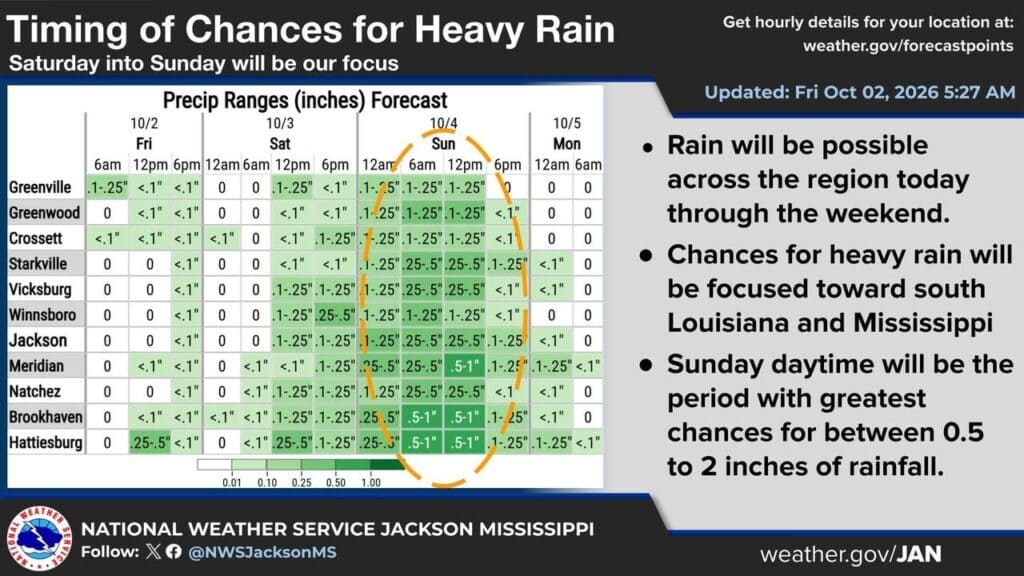
The NWS Jackson afternoon discussion keeps the greatest Saturday rain coverage in the Pine Belt. A nearly stationary front remains near the Natchez Trace, with additional showers developing overnight and locally heavy downpours possible Sunday.
Sunday’s updated daytime rain chances are 80% in Jackson and Meridian and 90% in Hattiesburg. Forecast highs are 81, 79 and 80, respectively. Rain can linger into early Monday before drier air arrives. The office’s afternoon watch-and-warning list had no Mississippi alerts; the coastal watch comes from the neighboring New Orleans/Baton Rouge office.
North Mississippi’s outlook has changed since Friday. The 12:45 p.m. NWS Memphis discussion says persistent cloud cover will hold much of the Mid-South to upper-60s to mid-70s highs today. Light showers over northeast Mississippi can expand northward overnight, with showers and isolated thunderstorms still possible across north Mississippi Sunday.
A reinforcing cold front late Sunday should end the rain and bring cooler, drier air. Early-week highs are expected in the upper 70s to lower 80s, with morning lows in the 50s. Coastal rainfall totals should not be applied statewide; northern residents should follow their local forecast for the timing of showers and the cooler turn.
Arthur survivors face today’s FEMA-assistance deadline
MEMA’s Friday reminder says residents affected by Tropical Storm Arthur have until Saturday, October 3, to apply for assistance. Residents can apply at DisasterAssistance.gov, call 1-800-621-FEMA (3362), or use the FEMA App. Visiting a Disaster Service Center is not required.
The agency says the Harrison County center closed Friday, while Pearl River and Stone county centers close Saturday. Anyone still needing to apply should use the listed channels today rather than wait for an office visit next week. Our full assistance report explains the phased closures.
FEMA assistance should be distinguished from the SBA’s separately announced October 3 physical-damage loan deadline. The SBA notice describes low-interest loans for eligible businesses, nonprofits, homeowners and renters, and a 60-day grace period for applications after the deadline. That loan provision should not be assumed to extend the FEMA application deadline in MEMA’s latest reminder.
Hinds County crash brings a separate I-55 travel warning
A Saturday morning Highway Patrol announcement shared by Byram police reports a crash involving an 18-wheeler and a passenger vehicle on northbound I-55 near mile marker 85 in Hinds County. Officials said one northbound lane was closed while emergency crews worked at the scene.
According to the announcement, the truck driver was not injured; the passenger-vehicle driver was taken to UMMC with injuries whose extent was not known. Our 9:02 a.m. report relays the warning. No reopening time is provided in the source, so check current traffic conditions before a trip and use caution near the scene.
This crash response is separate from Sunday’s planned demolition closure in Jackson. Both can affect I-55 travel, but the locations, causes and timing differ.
MDOT urges remote viewing of Sunday’s Jackson demolition
MDOT’s latest public notice asks spectators to avoid the former Department of Public Safety administration tower site and watch through an MDOT Traffic camera instead. Viewing is scheduled to start at 7:45 a.m. Sunday, October 4.
The department says I-55 in Jackson will close briefly from 7:45 to 8:15 a.m., for up to 30 minutes. Saturday morning’s demolition report adds that remote-viewing guidance to the closure information already reported Friday.
The governor’s October 1 release identifies southbound I-55 at Lakeland Drive and northbound I-55 at Fortification Street, plus restrictions on Woodrow Wilson Avenue, VA Center Drive, Museum Boulevard and University Drive. Check MDOT Traffic before leaving, especially for trips near the VA hospital and museum area. The times remain a planned work window, rather than a guarantee that traffic will resume at precisely 8:15.
Monday registration cutoff approaches for November election
The Secretary of State’s September 28 announcement sets Monday, October 5, as the voter-registration deadline for the November 3 general election. Applications can be submitted in person at the county circuit clerk’s office or mailed with a postmark no later than Monday.
Residents can use the state’s mail-in registration form and check their registration through the resources linked in the announcement. The approaching cutoff concerns registration; it is separate from Election Day and the later absentee-voting deadlines. Our DeSoto County coverage points readers to the local voter guide.
For eligible absentee voters, the state’s September 21 explanation says in-person voters will still use paper ballots but feed them into voting machines, with tabulation on election night. Mail-in procedures remain unchanged. Statewide Saturday in-person absentee hours are October 24 and 31, from 8 a.m. to noon; the last in-person absentee day is October 31. Direct eligibility or office-hours questions to the county clerk or the state elections hotline, 1-800-829-6786.
Olive Branch’s new movie series points to next Thursday
Olive Branch has launched Movies Under the Stars on the front lawn of City Hall. The city’s announcement, signed by Mayor Ken Adams, describes the first screening of Monsters Inc. and names Casper for the following Thursday night.
Our Friday report also relays the city’s plan for Domino’s and other pop-ups on Thursdays. The announcement does not supply a start time or cancellation policy, so check the city’s event information before making plans. This is a coming-week community option, not a screening scheduled for tonight.
Featured graphic: NWS Jackson’s October 2, 5:27 a.m. rain-timing forecast for its inland region. Current Saturday updates and the separate coastal flood watch are explained above. Credit: US National Weather Service Jackson Mississippi.
Compiled with AI assistance from Mississippi News Group coverage and linked official sources. See our editorial standards.