Mississippi heads into a dry, unusually warm week with a new Monday fire-danger outlook and a statewide severe-weather preparedness campaign beginning tomorrow. In local news, Prentiss County investigators are seeking help after a reported burglary and work-truck theft, while a superseding MDOT notice changes the Hattiesburg travel guidance carried in earlier coverage.
ADVERTISEMENT
This edition builds on Saturday evening’s briefing, with fresh morning forecasts, today’s MEMA announcement and newly covered transportation information. The sharp change in weather does not establish that every storm-affected service has resumed.
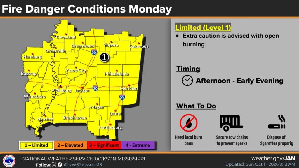
Monday fire outlook calls for extra caution with outdoor burning
NWS Jackson’s fire-danger graphic, updated at 9:18 a.m. Sunday, places its mapped forecast area at limited, Level 1 fire danger Monday afternoon into early evening. The outlook cites wind, low relative humidity and dry fuels as reasons wildfire spread could become a concern.
The graphic advises extra caution with open burning, compliance with local burn bans, securing tow chains to prevent sparks and disposing of cigarettes properly. Those precautions are particularly relevant as residents consider clearing limbs or other outdoor debris after the weekend weather.
This is a forecast for Monday, October 12, rather than a report of a fire already burning or a statewide burn ban. It provides a more specific time window and mapped risk than Saturday evening’s general dry-air discussion. Check local restrictions before burning; a forecast risk level does not override a county prohibition.
State’s fall severe-weather preparedness week starts tomorrow
Governor Tate Reeves has proclaimed October 12–17 Fall Severe Weather Preparedness Week, according to MEMA’s October 11 release. The agency says Mississippi recorded 80 tornadoes in 2025, including seven from October through December, underscoring the importance of the secondary severe-weather season.
Monday’s focus is making a plan. The remaining daily topics are severe thunderstorms Tuesday, tornado safety Wednesday, flash flooding Thursday, warning reception Friday, and mobile and manufactured home safety Saturday. MEMA encourages families to review emergency plans, shelter locations, supply kits, insurance policies and important documents.
ADVERTISEMENT
The NWS preparedness-week page adds that an effective plan needs a reliable way to receive emergency information, knowledge of watches and warnings, appropriate shelter and drills. A useful Sunday task is to agree where household members will go and how they will receive a warning before the next storm threatens.
The campaign is a preparedness effort, not an announcement that severe storms are forecast for Monday. It gives households, schools and workplaces a schedule for reviewing safety arrangements while conditions allow advance planning.
Early-week heat returns; a later cooldown remains in the forecast
NWS Jackson’s 6:03 a.m. discussion forecasts Sunday highs of 91 in Jackson and Hattiesburg, 88 in Meridian and 92 in Vicksburg, Greenville and Greenwood. Monday’s listed highs rise to 93 at most of those locations, with Meridian at 91.
The office expects mostly dry weather through Thursday, then a possible stronger cold front heading into next weekend. Its outlook gives weekend highs of 73–80, but the evolution of the weather system remains uncertain. That potential cooldown should not be read as relief arriving at the start of the workweek.
In Memphis’s 6:38 a.m. update, dry conditions return to the Mid-South today and last through Tuesday. Forecasters expect upper-80s to low-90s temperatures through at least Thursday and identify potential record heat, including at Tupelo. Northern areas near the Tennessee River may stay cooler today where clouds linger.
Jackson and Memphis both list no Mississippi watches, warnings or advisories in those morning discussions. These are forecasts for their respective areas, rather than a guarantee of conditions at every location.
Prentiss County seeks information after shed burglary and truck theft
The Prentiss County Sheriff’s Office says it received a call early October 10 reporting a burglary at the Supervisor District Shed, 283 County Road 8311. Its original public announcement says a man took vehicle batteries and miscellaneous items, then left in a supervisor’s white 2007 Ford F-150 four-door crew cab work truck.
The department describes the investigation as ongoing and asks anyone with information that could lead to an arrest to contact the sheriff’s department or Crime Stoppers. The announcement does not identify a charged suspect or establish a conviction.
Our full report published overnight has the available details. The incident date is Saturday, October 10; Sunday is the date of the site’s report, not a newly established date for the burglary.
Correction: Hattiesburg’s planned U.S. 98 closure was postponed
Drivers planning Sunday travel or Monday’s commute should use MDOT’s October 6 postponement notice for U.S. 98 over I-59 in Hattiesburg. The agency says the planned closure in both directions was postponed because of forecast severe weather and that it will notify the public when a new timeframe is determined.
The October 5 notice had scheduled structural maintenance from Friday evening, October 9, until 4 a.m. Monday, October 12. Our October 10 morning briefing repeated that earlier schedule without accounting for the superseding postponement. That travel guidance was incorrect.
The postponement does not establish a replacement work date, nor does it verify the absence of unrelated traffic restrictions today. Check MDOT Traffic for current travel information and follow posted signs. Readers should not plan around the old 4 a.m. Monday deadline as though the maintenance remained scheduled.
Biloxi transportation conference begins with Sunday registration
The Mississippi Transportation Institute conference is scheduled October 11–14 at the Beau Rivage in Biloxi. Its official event page and draft agenda list today’s registration and information desk from 2–6 p.m. on the Promenade.
Monday’s registration desk is scheduled from 1–5 p.m., alongside vendor setup. An asphalt track runs 2–5 p.m. Monday and requires separate registration. The main opening session is listed for 9–11:30 a.m. Tuesday, followed by an awards luncheon and afternoon technical and professional-development sessions.
The agenda identifies Federal Highway Administrator Sean McMaster as the opening-session keynote speaker and U.S. Sen. Cindy Hyde-Smith as the awards-luncheon keynote. These are scheduled appearances, not reports of remarks already delivered or new funding commitments.
The meeting brings transportation agencies and industry participants together around infrastructure, safety and professional training. Attendees should check the event’s registration and latest agenda before traveling; the page labels the schedule a draft, and some associated sessions require separate registration or an invitation.
Compiled with AI assistance from Mississippi News Group coverage and linked official sources. Featured graphic: National Weather Service Jackson, issued October 11 at 9:18 a.m.; public-domain NWS material. See our editorial standards and AI disclosure.